Popular local historical narratives have a fixation with Winnipeg’s boom years that lasted from about 1904 to 1913. Its position as the third-largest (and fastest-growing) city in the Dominion, an undisputed economic hegemony over the prairies, and a seemingly simple cartoon-like narrative of rich greedy WASPs and poor, exploited immigrants, make for a city that seems to contrast our own in many fascinating ways.
This period of dizzying growth did not last. The tragedy of the First World War, the trauma of the General Strike, and the frightening realization that Winnipeg’s favaourable economic conditions were fading away, would all give reason for the city to confront itself and all of the complexities of a being a big city it faced. (The degree to which it did that, of course, is a matter of debate.)
These photos show Winnipeg in the decades following the boom years. Recently made available by the City of Winnipeg Archives, many of the images are simply utilitarian documentation of a city government at work: aerial photographs of the built environment, public works improvements, and political figures and goings-on at City Hall. In spite of this, many of these photos possess a striking beauty. More importantly, they serve to illustrate the city during a largely forgotten period of it history, between unbridled growth and optimism at the start of the century, and urban decline and mega-scaled interventions at the century’s end.

The 1920s were the apex of North American downtowns. Cities had never been larger and its citizens more prosperous, and yet their downtowns still firmly maintained primacy as regional centres of business, shopping, and entertainment. This is a view of Main Street and McDermot Avenue—the heart of Winnipeg’s financial district.

North of the central business district, the Main Street strip faithfully maintained its long-standing reputation as “Winnipeg’s Bowery” for its dense collection of mean little structures that housed cheap hotels, bars, and pool halls. For those arriving to Winnipeg by Canadian Pacific rail in 1930, this was the scene they would survey after stepping out of the train station and walking a few hundred feet to the corner of Main and Higgins.

Further north still, Main Street faded out into streetcar suburbia. This view from 1932 looks north on Main at around Belmont Avenue in West Kildonan. The streetcar line dominates the roadway at a time when the Winnipeg region’s streetcar infrastructure reached its peak, both in terms of service in local neighbourhoods and outlying towns and suburbs. The tracks seen here extended out as far as Selkirk and Stonewall.

An aerial view of Portage Avenue and Memorial, circa 1935, showing a western edge of downtown characterized by houses and small commercial buildings. The massive Bay department store and Winnipeg Auditorium were recent variations to this rule. Meanwhile, the wedge of land where the Winnipeg Art Gallery would stand was the site of a large house and a rather opulent little gas station.

A rather idyllic Christmastime view of a service station at the corner of Fort Street and Graham Avenue, 1937.

While Main Street was the centre of trade and finance, Portage Avenue was the place for shopping, dining, and entertainment. At the centre of this was Eaton’s, the massive department store at the corner of Portage and Donald Street. Here, pedestrians walk past the store as Portage Avenue is dug up for new sewer pipes, 1938.

In spite of commercial and institutional uses encroaching on it, the downtown neighbourhoood south of Portage Avenue was still one of the most densely-populated areas of the city when this aerial shot was taken in 1947. Aside from those belonging to Eaton’s and The Bay, almost no large surface parking lots yet existed.
Within 10 years, the trees between Portage and Broadway would be cut down as streets were widened and converted to one-way traffic. Within 20, almost all of the original housing stock would be gone.

In the suburbs, decades of speculation and piecemeal development left many municipalities with economically inefficient demands for servicing: pipes, roads, and utilities. This aerial photo from 1943 suggests this was the case for the City of St. James (right), and the R.M. of Assiniboia (left).

“Junior Mayors” of Winnipeg pose in front of City Hall in 1947. In the background is the tiny, immaculately-maintained City Hall Park and a busy Main Street.

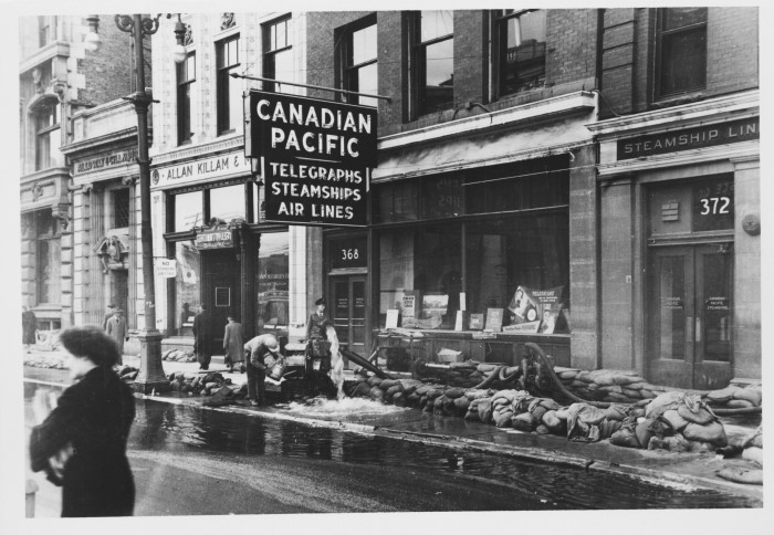
The Flood of May, 1950 was inescapable, even at Portage and Main. Here, hoses are used pump water from the flooded basements of office buildings that in less than 25 years would make way for the massive Trizec and Winnipeg Square developments.

The swollen Assiniboine River and an overworked sewer system left parts of Wolseley Avenue (seen here looking east from Arlington Street) underwater, in spite of the best efforts of sandbags piled up around utility covers.

Texture abounds on Portage Avenue at Vaughan Street, circa 1964. City planners hated this seemingly chaotic mess of overhead wires, neon signs, and awnings, while downtown boosters and public officials hated having an increasingly declining commercial strip on such a prominent thoroughfare. In less than 25 years, these ostensible problems would be addressed by the construction of Portage Place mall.

The corner of Donald Street and Graham Avenue, circa 1960, where the Centennial (and later Millennium) Library was built in the mid-’70s. Gas stations and taxi stands aren’t exactly the stuff of urbanist ideals, but the relatively small scale of these car-oriented land uses seen here, plus enough of a jumble of human-scaled texture, make this corner work just fine.
___
Robert Galston likes to write about Winnipeg, urbanism, and other very, very exciting topics. Follow him on Twitter @robgalston
For more, follow us on Twitter: @SpectatorTrib